

Wilderness
In 1964, Congress acknowledged the immediate and lasting benefits of wild places by passing landmark legislation that permanently protected some of the most natural and undisturbed places in America. The Wilderness Act established the National Wilderness Preservation System “. . . to secure for the American people of present and future generations the benefits of an enduring resource of wilderness.”
The Santa Fe National Forest manages four designated wilderness areas, comprising around 291,669 acres, or 18.7 percent of the forest. Two of the wilderness areas are completely managed by the Santa Fe National Forest and the other two have shared management with the Carson National Forest.
The Wilderness Act sets forth guidelines for the management of wilderness areas by maintaining four attributes used to describe wilderness character:
• untrammeled;
• naturalness;
• undeveloped; and
• outstanding opportunities for solitude or primitive and unconfined recreation.
Wilderness Areas
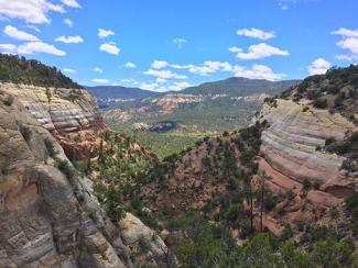
Chama River Canyon Wilderness
Photo Credit: New Mexico Wilderness Alliance photo by Zack BumgarnerDesignated by Congress in 1978, the Chama River Canyon Wilderness covers 50,300 acres, most of which is on the Coyote Ranger District of the Santa Fe National Forest. (About 2,900 acres of the wilderness are on the Carson National Forest.)
A 24.6-mile section of the Rio Chama received National Wild and Scenic River designation in 1988, a portion of which runs through the Chama River Canyon Wilderness. Relatively easy road access makes the Rio Chama popular among river rafters, canoeists and kayakers. Water levels are often dependent on releases from the El Vado Dam upstream.
Colorful sandstone bluffs and impressive rock formations that rise to high rims on both riverbanks make trail access to the river difficult. The Continental Divide Trail (CDT) traverses the wilderness and crosses the river on Scull Bridge.
Water in the Rio Chama brings the canyon to life. Trout flourish in the river, and onshore residents include mule deer, black bears, elk, coyote and mountain lions. Between 70 and 80 different bird species, including raptors, hawks and owls, can be found in the Chama River Canyon. Varying canyon elevations also provide a wide range of vegetation, from low-lying piñon-juniper woodlands to ponderosa pine and fir.
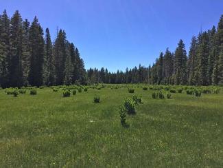
San Pedro Parks Wilderness
Photo Credit: New Mexico Wilderness Alliance photo by Zack BumgarnerSan Pedro Parks was first protected by the Forest Service as a “primitive area” in 1931. That term, rendered obsolete by later conservation efforts, recognized lands set aside for preservation and valued for recreational opportunities such as hunting, fishing and hiking. In 1941, the Secretary of Agriculture classified it as a “wild area” and set its acreage at 41,132 acres. It became the San Pedro Parks Wilderness in September 1964 as part of the original Wilderness Act.
Although the average elevation is more than 10,000 feet, the heart of the San Pedro Parks Wilderness is a high plateau that consists of grassy meadows, known as “parks,” interspersed with stands of Engelmann spruce, mixed conifer and aspen. The meadows flourish with bluegrass, oat grass, sedge, rush and Rocky Mountain iris.
San Gregorio Reservoir, a small irrigation reservoir pre-dating the wilderness designation, is the largest body of water. Several small streams that wander through the forest openings support strong trout populations, including the Rio Grande cutthroat trout. A large herd of elk summers in the wilderness.
The Continental Divide National Scenic Trail (CDT) crosses through the San Pedro Parks Wilderness from the nearby community of Cuba to the Rio Chama, the Carson National Forest and beyond. Its route follows the Las Vacas, Peñas Negras and Rio Capulin trail corridors.
Nine major trails and campsites with abundant water appeal to backpackers. Of the 100 miles of trails crisscrossing San Pedro Parks, the most popular are the CDT (Vacas Trail) to San Pedro Park (10.69 miles) and the Palomas Trail (3.63 miles), which joins the CDT.
In the fall, hunters come for elk, deer, bear and grouse. Cross country skiing and snowshoeing are popular during the winter.
The San Pedro Parks Wilderness receives about 35 inches of precipitation annually, making it one of the wettest spots in Northern New Mexico. July and August bring monsoonal weather patterns with afternoon rainfall, and the meadows can become boggy. Snowfall is heavy in winter, persisting into June.

Dome Wilderness
Photo Credit: New Mexico Wilderness Alliance photo by Zack BumgarnerThe 5,280-acre Dome Wilderness was designated by Congress in 1980. One of the smallest wilderness areas in the United States, the Dome Wilderness is bordered to the east by the larger Bandelier Wilderness on the National Park Service’s Bandelier National Monument. In spite of its relatively small acreage, the Dome Wilderness is a key part of an impressive wilderness complex and delivers rugged terrain, habitat for wildlife, diverse vegetation that includes wildflowers and wild strawberries, and numerous archaeological sites, including ruins similar to the ones found at Bandelier. Please respect the cultural significance of archaeological sites by leaving them undisturbed.
In 1996, the human-caused Dome Fire burned 16,500 acres, including large portions of the Dome Wilderness and Bandelier National Monument. In 2011, a downed power line started the 150,000-acre Las Conchas Fire which swept through the wilderness. Much of the Dome Wilderness is still recovering from these devastating wildfires.
Elevations peak at 8,200 feet, then drop to 5,800 feet at Sanchez Canyon. High points near Saint Peter’s Dome (which is actually not within the wilderness boundaries) provide sweeping vistas to the Caja del Rio Plateau and Sangre de Cristo Mountains to the east and the Sandia Mountains to the south.
The Dome Wilderness has miles of hiking trails, including the Saint Peter’s Dome Trail, the Capulin Trail and the Turkey Springs Trail. The Saint Peter’s Dome Trail (6.1 miles) starting on the north end near the Dome Fire Lookout is a good access point to the wilderness. It drops in elevation as it runs south past canyon walls and above sweeping vistas, then across Sanchez Creek, a fishless stream that often has very low or no water at all.

Pecos Wilderness
Photo Credit: New Mexico Wilderness Alliance photo by Jesse FurrCongress designated more than 168,000 acres as the Pecos Wilderness in 1964. An additional 55,000 acres were added in 1980, bringing the total to 223,333 acres across two forests: 198,597 acres on the Santa Fe National Forest and 24,736 acres on the Carson National Forest.
Deep and narrow canyons, broad ridges, forested slopes and rugged peaks characterize the Sangre de Cristo Mountains of the Pecos Wilderness at the southern end of the Rocky Mountain chain.
On the west front, steep canyons drain toward the Rio Grande. In contrast, the eastern side of the Sangres is characterized by the broad mesas and grassy meadows of the upper Pecos River Valley, including the 20.5 miles of the Pecos River that received National Wild and Scenic River designation in 1990.
High-country elevations range from 8,400 feet to 13,103 feet at the top of Truchas Peak, the state’s second highest summit (behind Wheeler Peak at 13,159 feet). The landscape features everything from 100-foot waterfalls and crumbled talus slopes to dramatic rock cliffs, towering peaks and wildflower meadows. Engelmann spruce, corkbark fir, ponderosa pine, Douglas fir, white fir, limber pine, bristlecone pine and aspen are the predominant tree species.
Wildlife is equally diverse, including elk, deer, bear, turkey and one of America’s healthiest herds of Rocky Mountain bighorn sheep. Fifteen lakes and 150-plus miles of sparkling streams offer first-rate fishing, including rainbow trout, brown trout and the Rio Grande cutthroat trout, New Mexico’s state fish.
The average annual precipitation is 34-40 inches, half of which comes from summer rains and half from winter snows. Temperatures range between a daytime high of 80° in the summer to winter temperatures below zero. July and August are usually rainy months with daily “monsoon” showers in the afternoon. Daytime temperatures can drop dramatically when monsoonal storms move in. Nights can be cold year-round, and snowfall can begin as early as October.
Recommended Wilderness Management Areas
Lands that the Forest Service has determined, through land management planning, to have the potential to be included in the Wilderness Preservation System comprise the Recommended Wilderness Management Area. Congress reserves the authority to make final decisions on wilderness designation. The intent of this management area is to provide management direction that preserves the existing wilderness characteristics in these areas, so they are present if Congress acts to designate them. Management of recommended wilderness areas does not alter or restrict existing rights.
Ecosystem services provided by recommended wilderness management areas include supporting ecosystem services such as nutrient and water cycling; biodiversity; and regulating ecosystem service such as water filtration, air quality protection, and climate change adaptation. Provisioning ecosystem services of food from hunting and foraging also occur here. Recommended wilderness management areas also provide abundant cultural ecosystem services in the form of recreation, opportunities to connect with nature, providing baselines on unhindered ecosystem processes for ecological research, and the preservation of cultural traditions and historical features.
This management area consists of five areas across four districts of the Santa Fe National Forest.
Dark Canyon Recommended Wilderness Management Area is 2,218 acres and located in the Coyote Ranger District. It lies north of the Chama River Canyon Wilderness and south of the Rio Chama Wilderness Study Area on Bureau of Land Management land just across the Forest Service boundary. The topography of this area is steep and rugged with three canyons that incise the polygon. Vegetation is dense and the dominant vegetation type is mixed conifer and Gambel oak with pockets of ponderosa pine and piñon-juniper in the southern portion of the area. The polygon has many common forest species as well as rare species such as Rio Grande chub and Rio Grande sucker. No developments exist in the area. This terrain contributes to a level of challenge and self-reliance within the area and a sense of solitude.
White Rock Canyon Recommended Wilderness Management Area is 10,280 acres and located in the Española Ranger District. It lies on the western portion of the Caja del Rio plateau and along the Rio Grande River. Across the river is the Bandelier Wilderness in Bandelier National Monument. The terrain includes White Rock Canyon and several arroyos. Vegetation is dominated by piñon-juniper, sagebrush, open grassland, and ponderosa pine patches along the western edge. Wildlife is diverse, in part because the area covers both grasslands and the riparian area around the Rio Grande. The area is an important bird area and includes species such as pinyon jay, gray vireo, southwestern willow flycatcher, western burrowing owl, and golden eagle. Evidence of man is predominated by historic petroglyphs and archeological sites. The western portion of the Caja del Rio is difficult to access and terrain across the area is varied, from rolling grasslands to more rugged cliffs and escarpments along the boundaries. Although close to the metropolitan centers of Santa Fe and Los Alamos, a sense of solitude can be easily achieved in this rarely visited and expansive area.
Thompson Peak Recommended Wilderness Management Area is 9,483 acres and located in the Pecos/Las Vegas Ranger District. Its western boundary follows the Pecos Wilderness and Santa Fe watershed and extends south to Thompson Peak. The vegetation is dominated by ponderosa pine and mixed conifer with some aspen. The topography is rugged and includes many drainages with perennial and seasonal streams. This terrain and the lack of amenities provides a high level of challenge or risk for visitors. The area offers many high-quality primitive recreation opportunities such as hiking, hunting, and backpacking.
Enchanted Lake and Grace Tract Recommended Wilderness Management Areas are 925 acres and 945 acres, respectively. Both are located in the Pecos/Las Vegas Ranger District, in the northeastern corner of the Santa Fe NF and adjacent to the Pecos Wilderness. Vegetation consists of spruce-fir and aspen, with some ponderosa pine along the lower elevations of the east slopes. Enchanted Lakes has more scrub oak and vegetated rocky areas. The topography for both areas is rugged and steep and the Grace Tract area includes a waterfall. No improvements are found within these areas and both have abundant opportunities for primitive recreation and solitude.